THE GEOLAYERS PLATFORM

One spatial workspace.
From data to decision.

Bring mapping, GIS analysis, planning intelligence, Earth observation, GeoAI, automation and professional outputs together in one connected project environment.

Browser-based GISGeoAI + spatial analyticsSouth African context
PRODUCT PREVIEW

See GeoLayers Studio in action

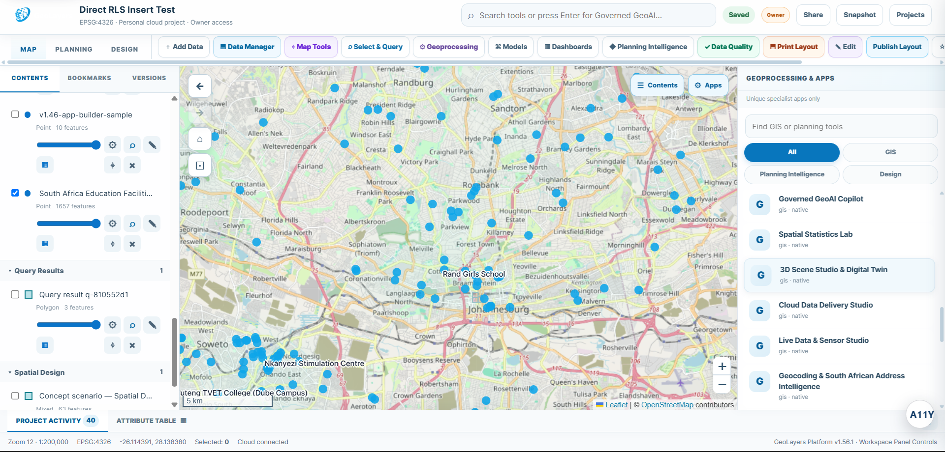
GeoLayers Studio workspace showing project layers, map, tools and specialist GIS applications
Geolayers Studio Workspace.
WORKSPACE ARCHITECTURE

A GIS workspace designed around the project

GeoLayers keeps the map, data, analysis history and outputs together so users can work from one project context instead of rebuilding the same evidence across separate applications.

Project-centred workspace

Each project keeps its layers, source files, map state, metadata, analysis outputs and collaboration context together. The workspace is designed for continuity: open a project today, return later and continue from the same spatial context.

Data and layer control

Add vector and raster data, organise map contents, inspect attributes, manage visibility and move from raw layers into analysis without leaving the browser.

Specialist GIS apps

Open purpose-built modules for Earth Observation, GeoML, spatial statistics, mobility, 3D scenes, digital twins, data quality, planning intelligence and more from the same project.

Outputs that remain usable

Publish analysis results back into the project as layers that can continue into cartography, dashboards, automation, APIs, governance or client-ready outputs.

DAY-TO-DAY WORK

What the Studio is built to handle

The platform is designed for professional users who need more than a viewer: it combines common GIS operations with advanced analytical and operational capabilities.

  • Create and maintain cloud GIS projects directly in the browser.
  • Edit and query vector data, inspect attribute tables and perform common geoprocessing operations.
  • Work with raster and Earth Observation data, spectral indices and change-detection outputs.
  • Create predictive spatial models, network analyses, logistics scenarios and digital-twin simulations.
  • Design maps, dashboards, layouts and focused web applications without rebuilding the underlying dataset.
  • Extend projects through spatial automation, developer APIs, OGC services and enterprise governance.
CONNECTED WORKFLOW

Move through analysis without breaking context

A professional GIS workflow rarely ends after one tool. GeoLayers is structured so each stage can feed the next.

Prepare the projectLoad authoritative data, inspect fields, confirm coordinate context and organise the map around the decision you need to make.
Analyse with the right moduleUse vector, raster, network, planning, GeoAI, GeoML or simulation tools while keeping the source evidence visible.
Review the resultInspect output attributes, compare scenarios, validate assumptions and publish useful results back into the project.
Communicate or operationaliseTurn the result into a map, dashboard, app, API, automated workflow or enterprise evidence package.
WHO IT IS FOR

One platform for spatial professionals and organisations

GeoLayers is designed for planners, GIS professionals, analysts, environmental teams, infrastructure managers, logistics teams, researchers, developers and organisations that need spatial evidence to support decisions.

G

GIS professionals

A modern browser workspace for data preparation, analysis, cartography, automation and spatial delivery.

Explore →
P

Planning teams

Connect land-use controls, spatial evidence, site assessment and planning outputs in one project.

Explore →
E

Enterprise teams

Add governance, recovery, audit evidence, APIs and administration to shared spatial workflows.

Explore →